Machine-readable: manifest · index · English Markdown
Get Started
Meet 01Spatial: Space-as-a-Service
01Spatial is a Space-as-a-Service platform built on our distinctive UX-first visual positioning technology (UX-first VPS). Space-as-a-Service is an innovative concept introduced by 01Spatial: visual positioning turns a museum, stadium, mall, factory, or other real venue into a high-value spatial product that can be located within, programmed, and operated digitally.
Traditional VPS products usually answer only “where is the device?” 01Spatial combines scan-to-map, visual positioning, no-code AR content, indoor and outdoor navigation, robot localization, and spatial analytics in one platform, with centimeter-level, campus-scale visual positioning for large real-world environments. A physical venue becomes an asset that can continuously deliver digital experiences and operational services.
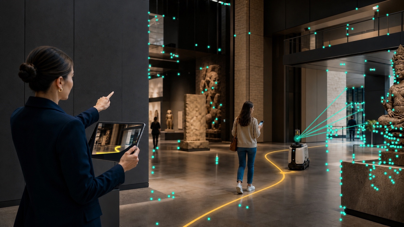
The teal marks are visual feature points derived from repeatable, stable image corners; they are not decorative particles spread uniformly across surfaces. Fine teal rays show the robot camera observing selected environment features; the robot estimates its pose from continuous frames, then follows the yellow navigation route. One Spatial Map connects a Space Owner with Space Users. A Space User can be a person using AR navigation and experiences, or a robot using localization and navigation to perform work.
Who uses Space-as-a-Service?
- Space Owners are the organizations that operate museums, stadiums, malls, factories, and other venues. They build and manage Spatial Maps, publish AR and navigation experiences, and inspect robot trajectories and spatial analytics.
- Space Users are people or robots that use the venue. Human Space Users include museum visitors, shoppers, and on-site employees who use AR guidance, navigation, and interactive experiences. Robot Space Users rely primarily on localization and navigation for inspection, delivery, or other tasks.
Space Owners provide and manage spatial services; Space Users consume them. Both roles share the same durable Spatial Map and coordinate system, but they have different goals, interfaces, and permissions.
From spatial capture to continuous operations
01Spatial is not an isolated localization endpoint. One platform carries the complete path from capture to production and operations:
- Scan to map: build a Spatial Map from a standard camera, 360° camera, mobile 3D scanning app, or professional LiDAR system.
- Localization and navigation: localize phones, AR devices, and robots in the same coordinate system and support continuous indoor and outdoor navigation.
- No-code content authoring: place text, images, 3D models, and interactions in the real venue with Space Studio, then update them without rebuilding the map.
- Spatial operations: analyze and replay movement so a one-time 3D asset becomes continuously manageable spatial infrastructure.
- Flexible deployment: use the cloud service or a private deployment according to project requirements.
This is the essential difference between 01Spatial and a VPS-only vendor: 01Spatial delivers the complete loop from spatial capture, mapping, and localization to content authoring, navigation, and movement analytics, turning a venue into an environment ready for AR applications and robotics.
Start by completing the first Spatial Map.
1. Choose an input type
Scanning and mapping are organized around four source-data types:
| What you already have | Documentation path |
|---|---|
| Video from a phone, action camera, or standard camera | Standard camera video |
| Video from a 360° camera | 360° camera video |
| Exported scan data from third-party 3D reconstruction apps such as Polycam or KIRI Engine | Mobile 3D scanning |
| Exported data from professional static or handheld LiDAR reality-capture scanners | LiDAR scan |
Do not switch input types by renaming files. Each path expects a different data structure and uses a different mapping process.
2. Build a Spatial Map
- Create a Map in Portal and choose the input type that matches the source data.
- Capture or prepare the data with the corresponding guide, then upload it.
- Standard camera and 360° camera video must provide a real-world size and coordinate reference: place 01Spatial Reference Boards during the scan, or configure surveyed GCPs (Ground Control Points) in Map Configurator after parsing. Despite the name, a Ground Control Point does not have to be on the floor.
- Start the build and wait for the Map to become ready.
Polycam, KIRI Engine, and LiDAR paths use pose or geometry information supplied by their source data and do not require Map Configurator.
3. Manage maps and author content
After a map is ready, manage it from Spatial Maps. In Space Studio, use the left Map Panel to inspect map properties and run localization tests. Use the right Content Panel to add basic 3D objects or import complex GLB / glTF models.
For Space Owners, Analytics records localization activity and movement. A factory can review robot inspection routes and execution history; a mall, attraction, or museum can study navigation hot spots, common routes, and dwell patterns.
Content is separate from the underlying map. Updating text, models, or interactions usually does not require rebuilding the map.
4. Validate localization and launch AR
Validate the map with the localization test built into Space Studio, then choose a delivery path:
- Use the WebXR client on Android.
- Use the App Clip client on iOS.
- Use the WeChat Mini Program in WeChat.
- Integrate the localization API into a generic client.
- Start Unity or WeChat Mini Program development from a template.
Read next
| Goal | Recommended guide |
|---|---|
| Understand the complete product flow | How it works |
| Start a spatial scan with a phone or standard camera | Scan a space with a standard camera |
| Validate a map before client integration | Run a localization test in Space Studio |
| Integrate localization into a generic client | Localization API & AR integration |
Recommendation: Start with a small test map and validate the complete capture, build, and localization loop before expanding to the full venue.