Machine-readable: manifest · index · English Markdown
Draft translation: this English page is available for review and is not yet the production default.
Explore a map
The left Map Panel in Space Studio is for inspecting the map itself: points, mesh, origin, and mapping-camera poses. For query-image validation, continue to Run a localization test in Space Studio.
Open the map
Find a Ready map in Spatial Maps, select Open, and wait for Space Studio to finish loading. Drag with the left mouse button to orbit, use the wheel to zoom, and drag with the right mouse button to pan. On a trackpad, use one finger to orbit and a two-finger gesture to zoom or pan. Use the orientation gizmo for axis-aligned views.
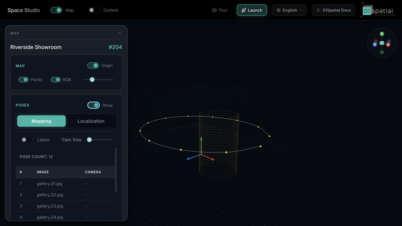
MAP display controls
| Control | Purpose |
|---|---|
| Points | Show or hide sparse 3D localization points. |
| RGB | Use source colors; turn it off for a uniform structural view. |
| Point Size | Change only on-screen point size, not map accuracy. |
| LiDAR | On supported maps, switch between sparse points and a downsampled LiDAR cloud. |
| Mesh | Show available surface geometry. |
| Wire | Overlay mesh triangles for continuity inspection. |
| Opacity | See points and surfaces together. |
Start with Points + RGB, then enable only the geometry needed for the current inspection.
Origin
Origin shows (0, 0, 0) and the map's X, Y, and Z axes. It defines the coordinate frame used by Content, localization poses, and robot routes.
01Spatial lets an authorized Space Owner place and orient a custom origin instead of being locked to the coordinate frame generated during mapping. This makes it possible to align (0, 0, 0) with an entrance, surveyed reference, or CAD/BIM datum, and align the axes with a building, aisle, or navigation direction.
- Enable Origin, then select Edit.
- Choose Move or Rotate.
- Drag an axis, or enter precise X, Y, and Z values under Pos or Rot.
- Review the adjustment, then select Save and reload the map to verify it.
Saving a custom origin does not rebuild the map or change its geometry or localization accuracy. It changes the coordinate frame in which results are expressed. Set it before publishing Content, integrating the localization API, or defining robot routes. On a map already in production, coordinate the change with every integration that consumes map coordinates.
The reset control inside the editor restores the state from the start of the current edit. Outside the editor, Reset clears the saved custom origin and returns to the default SfM origin. Cancel discards unsaved changes.
POSES
In Mapping, the POSES list represents cameras used by mapping:
- Show toggles all camera frustums.
- Labels toggles image names.
- Cam Size affects only frustum visualization.
- Selecting an image focuses its camera and opens the image preview.
A healthy path continuously covers entrances, turns, and connections. Large gaps or cameras concentrated along one direction indicate coverage worth reviewing. Pinhole is an administrator diagnostic for certain panoramic inputs and is not required for normal viewing.
Panels
Select the Map Panel title to collapse its body, or use the top Map button to hide the entire panel. On desktop, drag the panel edge to resize it. Hiding a panel does not unload the map.
Review order
- Check extent and discontinuities with Points.
- Check mapping-camera continuity at entrances and transitions.
- Compare available Mesh geometry with the points.
- Confirm the agreed Origin.
- Finish with a localization test.