Machine-readable: manifest · index · English Markdown
How it works
01Spatial first turns a real place into a persistent Spatial Map. Two roles then use that map for different jobs: a Space User obtains positioning, navigation, or AR / MR experiences, while a Space Owner manages maps, content, and venue operations. A Space User can be a person or a robot.
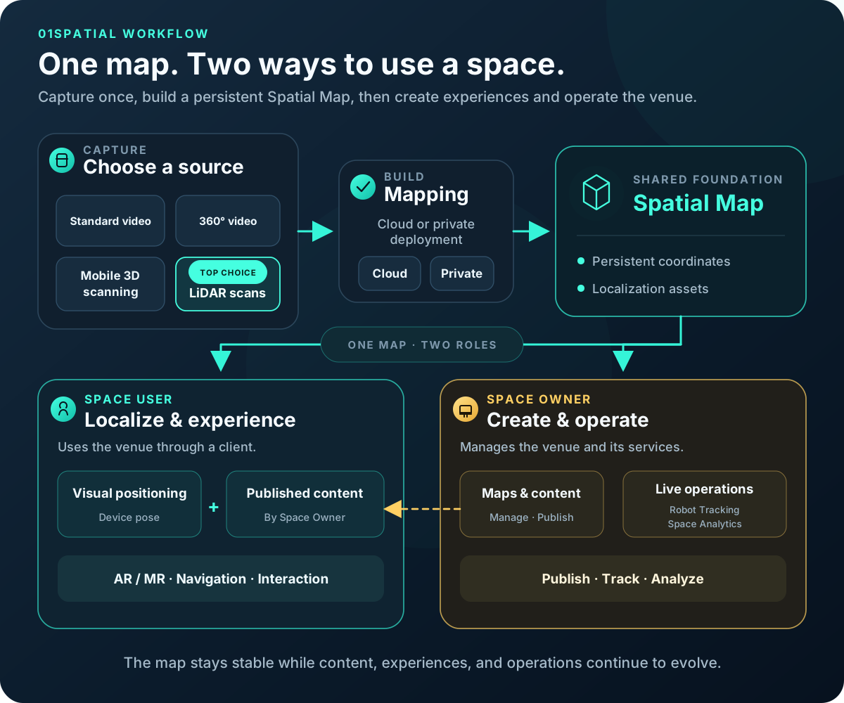
The two role paths are not consecutive processing stages. Space Users and Space Owners have different goals, entry points, and permissions. They share one Spatial Map but use it in different ways. Select the image to view it at full size.
1. Scan the real space
Choose the input type that matches the source data:
- Standard camera video: continuous video recorded with a phone, action camera, or other standard camera.
- 360° camera video: equirectangular video recorded with a 360° camera.
- Mobile 3D scanning: exported scan data from third-party reconstruction apps such as Polycam or KIRI Engine.
- LiDAR scans (top choice): exported data from professional static or handheld LiDAR reality-capture scanners; this path usually provides the most stable and complete geometric foundation.
Standard camera and 360° camera video must provide a real-world size and coordinate reference. Place 01Spatial Reference Boards during capture, or configure surveyed GCPs (Ground Control Points) in Map Configurator after parsing. Mobile 3D scans and LiDAR data already carry pose or geometry information and follow their own preparation paths.
2. Build a Spatial Map
The mapping service can run in the 01Spatial-managed Public Cloud or in a private customer environment. Both deployment models turn the input into the same core asset: a Spatial Map.
A Spatial Map is more than a viewable 3D model. It provides:
- A persistent, stable coordinate system for the real place.
- The map assets clients need for visual positioning.
- A shared spatial reference for content, device trajectories, and operational data.
The map must be ready before it can be used by the Space Studio localization test, localization API, AR clients, or venue-operations features. Capture coverage, image quality, and the accuracy of the spatial reference directly affect downstream results.
3. Two roles, different responsibilities
| Role | Who this role represents | Primary goal | Typical entry points |
|---|---|---|---|
| Space User | A person using AR navigation or experiences, or a robot that needs localization and navigation | Determine its position in the venue and use navigation, content, or task services | WebXR, App Clip, WeChat Mini Program, mobile apps, AR devices, and robot clients |
| Space Owner | The organization and administrators operating a museum, stadium, mall, factory, or other mapped venue; this does not necessarily mean the legal owner of the property | Manage maps, author and publish content, manage devices, and analyze venue activity | Spatial Maps, Space Studio, operations systems, and management APIs |
The key relationship is: the Space Owner creates and publishes spatial services; the Space User consumes those services after localization. For a person, that service may be AR guidance, navigation, or interactive content. For a robot, it is primarily the position and route information needed to navigate and complete a task.
4. Space User: localize and experience the venue
A Space User can be a person using AR navigation, guidance, or interactive experiences, or a robot that needs visual localization and navigation. Neither needs access to the map-management console:
- A phone, AR device, or robot camera sends a camera image and the intrinsics for those pixels.
- 01Spatial returns the device's 6-DoF position and orientation in Spatial Map coordinates.
- A human-facing client uses the pose to display the Space Owner's AR content or navigation route. A robot uses the pose for navigation and task execution.
Visual positioning plus published content creates AR / MR, indoor navigation, tours, in-context guidance, or spatial interaction. Validate localization with the tool built into Space Studio first, then choose Android WebXR, iOS App Clip, the WeChat Mini Program, the localization API, the Unity template, or the WeChat template for the product client.
A robot is one kind of Space User. The robot uses visual positioning to obtain its pose and navigate; the Space Owner centrally monitors and manages robot positions, routes, and history.
5. Space Owner: author and operate the venue
The Space Owner maintains the map and business content and controls what Space Users can see and use:
- Spatial Maps: create maps, inspect build status, move or transfer maps, and open downstream tools.
- Map Panel: inspect and switch maps in Space Studio, including points, meshes, the origin, and mapping-camera positions.
- Content Panel: add, edit, and publish 3D models, guidance, navigation nodes, and interaction hotspots.
- Robot Tracking: monitor robots or other managed devices in the shared map coordinate system.
- Space Analytics: record and analyze localization sessions, trajectories, and venue activity for operations decisions.
Maps and content have different lifecycles. A map defines the real place and its coordinate system; content defines what an application displays or manages in that system. Most content changes can therefore be published without scanning or rebuilding the map again.
Three core objects
| Object | Purpose |
|---|---|
| Map | Coordinate system, mapping result, and localization assets for one real place |
| Project | Organizes multiple Maps so clients can localize across a larger area |
| Content | Spatial content authored and published by a Space Owner for Space Users to consume in Map coordinates |
These objects are related but can be updated independently. A map can remain stable for a long time, a Project can add or remove Maps, and content can be changed and republished on its own lifecycle.